Haddonfield Heights Map Guide: Official Landmarks
See what the official Haddonfield Heights flythrough confirms, including the Strode house, Myers house, Lampkin Lane, water tower, and launch-map context.
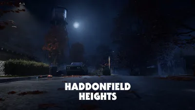
What is Haddonfield Heights?
Haddonfield Heights is a neighborhood map built around quiet residential streets and a dark local history. The official flythrough article introduces it as a place marked by the horrors of Halloween night in 1963, while the later four-map overview confirms it as one of the maps launching with Halloween: The Game. Its appeal is the contrast between an ordinary family neighborhood and the history attached to its landmarks.
The dedicated official reveal is titled Haddonfield Heights Map Flythrough and was published on December 4, 2025. It gives players a deeper visual look through a flythrough and three screenshots, but its written text is intentionally brief. The official overview published on September 1, 2026 supplies the clearest landmark list: the Strode house, Lampkin Lane, the abandoned and allegedly haunted Myers house, modest single-family homes, and an enormous water tower.
The official homepage places the game in Haddonfield on Halloween night in 1978 and describes a 1v4 asymmetrical horror experience in which players can act as Michael Myers or a Hero of Haddonfield. The map overview describes four unique multiplayer maps. That makes Haddonfield Heights a confirmed launch setting, but it does not turn the flythrough into a complete tactical diagram or prove how the map is used outside the officially described multiplayer context.
Which Haddonfield Heights landmarks are confirmed?
The current official materials identify five main visual anchors for Haddonfield Heights.
- The Strode house is the familiar residential landmark named in the four-map overview. It is presented as part of a quaint, family-friendly neighborhood and as one of the recognizable locations tied to the original film world.
- Lampkin Lane is the street connected to the town’s dark history. The flythrough article says residents gather at the water tower to share the twisted tale of Lampkin Lane, while the four-map overview places the street near the Myers house.
- The abandoned Myers house is described as allegedly haunted and as the place where tragedy struck the town years earlier. The official wording establishes its reputation and narrative significance; it does not state its exact accessible rooms or gameplay function.
- Modest single-family homes fill out the residential identity of the neighborhood. The overview does not provide a house-by-house list, an address system, or a complete structure count.
- The water tower is described as enormous and looming over the quiet streets. It is both a skyline marker and part of the neighborhood’s folklore, but the official reveal does not call it a playable objective, a safe position, or a route landmark with a fixed interaction.
These details answer the basic search question of what is on the Haddonfield Heights map while keeping the evidence boundary visible. The official sources show a residential district with recognizable film-related locations and a water tower. They do not publish a coordinate grid, an overhead map, or a list of every accessible interior.
What atmosphere does the official reveal establish?
Haddonfield Heights is presented as deceptively normal. The neighborhood is quaint and family-friendly, yet the official writing keeps returning to the 1963 tragedy, Lampkin Lane, and the allegedly haunted Myers house. The result is a suburban horror setting where the danger comes from the history beneath familiar streets rather than from a visibly industrial or commercial theme.
The time framing is important. The earlier tragedy happened on Halloween night in 1963, and the later overview says the nightmare has returned 15 years later. That places the map within the 1978 film-inspired setting described on the homepage. It does not, however, verify that every house or street reproduces a specific film shot, or that a visual reference has a direct gameplay consequence.
The flythrough and screenshots are useful for visual orientation. They can help a player recognize the water tower, residential streets, and film landmarks once the game is available. They should still be treated as previews. A camera pass can show the appearance of an area without proving which doors open, which fences can be crossed, or how players move between two visible locations during a match.
What remains unverified about the map?
As of September 4, 2026, the official reveal pages used here do not verify the full Haddonfield Heights layout. They do not give map dimensions, an overhead floor plan, fixed player spawn points, exact escape locations, item or weapon locations, objective order, shortcut routes, traversal times, or an optimal path. They also do not establish whether every named landmark is accessible in the same way for every role or match state.
The phrase “abandoned and allegedly haunted” is narrative description, not a mechanical specification. Likewise, a water tower that looms over the streets is not automatically a lookout, objective, spawn, or extraction point. The Strode house and Myers house are confirmed landmarks, but this source set does not confirm their complete interiors, entry points, or the actions a player can perform there.
How should routes be verified after launch?
Start with a written test question such as, “Can a player travel from the Strode house to Lampkin Lane without using an unverified shortcut?” Record the platform, game version, date, match type, and every visible landmark passed on the run. A screen recording is preferable to memory because it preserves turns, blocked paths, doors, and any conditions that changed during the match.
Repeat the test in multiple matches and separate stable geography from match-dependent events. If a path appears blocked in one run and open in another, record the condition instead of declaring the route fixed. If a player reaches the Myers house from a direction shown in the flythrough, that confirms one observed connection, not the only connection or the fastest route. Route articles should include their evidence and avoid “best route” language unless alternatives have been compared.
For the wider launch set, compare the evidence for Haddonfield Heights with the official descriptions of Haddonfield Town Center, Orange Grove Estates, and East Haddonfield. The maps share a Haddonfield setting, but the official pages do not say that a route, landmark rule, or layout convention transfers from one map to another.
How does Haddonfield Heights fit the launch map list?
The official overview names four launch maps: Haddonfield Town Center, Haddonfield Heights, Orange Grove Estates, and East Haddonfield. Haddonfield Heights is the residential, history-heavy entry in that list based on the material currently available. That is a thematic description, not a claim about its size, difficulty, or competitive role.
This page was verified on September 4, 2026, before the official September 8, 2026 launch date. When post-release route data becomes available, update the page with recorded observations, version information, and clear distinctions between fixed landmarks and match-dependent behavior. Until then, the flythrough and official overview are enough to identify the map and its confirmed places, but not enough to publish a reliable route guide.
Sources
Evidence gallery
Related field reports
maps
East Haddonfield Map Guide: Official Landmarks
Learn what the official four-map overview confirms about East Haddonfield, including Rabbit in Red, Phelps Garage, farmland, and route-verification limits.
maps
Haddonfield Town Center Map Guide: Official Landmarks
Learn what the official reveal confirms about Haddonfield Town Center, its downtown landmarks, four-map launch context, and post-release route verification.
maps
Orange Grove Estates Map Guide: Official Landmarks
Review the official Orange Grove Estates reveal, including multi-story homes, the park, Wallace and Doyle residences, and what routes still need launch testing.
Was this report useful?
Response recorded