Orange Grove Estates Map Guide: Official Landmarks
Review the official Orange Grove Estates reveal, including multi-story homes, the park, Wallace and Doyle residences, and what routes still need launch testing.
What is Orange Grove Estates?
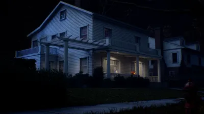
Orange Grove Estates is the third official map reveal for Halloween: The Game. The official article presents it as an upscale Haddonfield suburban neighborhood with picturesque multi-story houses, broad residential spaces, and recognizable locations from the original film. The four-map overview confirms it as one of the four maps launching with the game alongside Haddonfield Town Center, Haddonfield Heights, and East Haddonfield.
The official homepage describes Halloween: The Game as a 1v4 asymmetrical horror experience set in Haddonfield on Halloween night in 1978. Within that wider setting, Orange Grove Estates is the polished, family-oriented suburb that hides a more dangerous traversal environment than its appearance suggests. The reveal repeatedly contrasts attractive homes and a wholesome park with balconies, fences, hedges, winding paths, and open sightlines.
This article separates those confirmed environmental descriptions from information that is not yet public. The official sources do not publish an overhead map, a scale, or a full interaction guide. They establish the theme and named landmarks, but they do not verify where a player spawns, where an escape is located, or which route is fastest in a live match.
What structure does the official reveal confirm?
Orange Grove Estates is built around large homes with multiple stories. The reveal specifically describes movement upstairs, downstairs, through long hallways, and through garages. It also mentions detached garages and balconies in the broader map overview. Those details confirm a vertical and interior-focused visual identity, but they should not be turned into a floor plan without gameplay evidence.
The official article also names several outdoor features:
- Fences and hedges are positioned throughout the map and are described as blocking escape paths and creating chokepoints.
- The neighborhood park includes a playground, basketball court, picnic areas, and interconnected winding paths.
- Open areas between structures create a different traversal experience from the enclosed home interiors and provide longer sightlines.
- Expansive streets are described as places where Civilians can drive repaired vehicles and bike around the neighborhood.
The source uses these details to explain why matches can feel different across interior and exterior spaces. It does not say that every fence is impassable, that every hedge has the same collision behavior, or that the park is always a safe temporary barrier. The page records what the official reveal says about the environment and leaves exact behavior to post-release testing.
Which film landmarks are on Orange Grove Estates?
The most prominent confirmed landmarks are the Wallace residence and the Doyle house. The official reveal places the Wallace residence at the top of Orange Grove Estates and identifies it as the home where Annie Brackett regularly babysits. It invites players to move from room to room and explore the backyard shed, but it does not provide a complete list of accessible rooms or interactions.
Across the street from the Wallace residence is the Doyle house, associated with Laurie Strode’s babysitting role. The article says fans will recognize signature rooms throughout this multi-story home and describes multiple points of entry. That is useful landmark information for players trying to identify the Orange Grove Estates map, while still not proving which entrances remain open in every match or whether one entrance is safer or faster.
The four-map overview repeats the Wallace and Doyle residences as familiar locations from the original film. Their presence gives Orange Grove Estates a strong film-location identity, but a recognizable house is not automatically an objective, spawn area, escape, or shortcut. A post-release guide should verify those functions separately rather than inheriting them from the film connection.
How does the map’s traversal theme differ?
The official reveal describes a deliberate mix of enclosed and open movement. Large houses create upper-level situations involving multiple floors, hallways, garages, windows, and more than one entrance. Outside, fences, hedges, playground equipment, winding paths, and broad streets change how players read distance and visibility. The article also says the location leans toward the larger side and warrants exploring options.
Those statements explain the intended atmosphere: Orange Grove Estates looks idyllic, but the environment contains many places to lose sight of a threat, create a temporary barrier, or expose a long line of sight. They do not identify an optimal loop, a guaranteed hiding place, or a universal strategy for Michael or Civilians. The official wording is a design overview, not a competitive route ranking.
What remains unverified about the map?
As of September 4, 2026, the official reveal and four-map overview do not publish the complete playable geometry of Orange Grove Estates. They do not verify map dimensions, exact house layouts, fixed player spawn points, escape locations, item or weapon locations, objective order, shortcut connections, route lengths, or a best route. They also do not establish whether a balcony, garage, fence, hedge, or park feature behaves identically in every match.
Even official phrases require careful reading. A house having multiple points of entry does not prove that every door is usable. A park having winding paths does not prove that those paths connect to a particular escape. A street being suitable for repaired vehicles or bikes does not prove that a vehicle always spawns there. Those are all reasonable launch-testing questions, but they are not confirmed facts in the pre-release source set.
How should routes be verified after launch?
Define the route before testing it. Record whether the run starts at the Wallace residence, the Doyle house, the park, or another clearly named landmark, and write down the intended destination. Capture the complete run with the platform, game version, date, match type, and any relevant interaction visible in the recording. Do not describe a route as starting at an unnamed spawn until the spawn has been independently confirmed.
Repeat the same path across multiple matches. Mark which sections are fixed geography and which sections depend on doors, objectives, vehicles, items, or other changing conditions. Test at least one alternative when making a comparison, then report the evidence rather than assuming the shortest-looking line is best. A route may be useful without being optimal; the page should say which claim the recording actually supports.
For launch-map comparisons, see Haddonfield Town Center, Haddonfield Heights, and East Haddonfield. The official sources give each district a different visual identity, but they do not establish shared route rules or direct playable connections between maps.
How does Orange Grove Estates fit the four-map launch?
The official launch overview lists Haddonfield Town Center, Haddonfield Heights, Orange Grove Estates, and East Haddonfield as the four launch maps. Orange Grove Estates is the upscale suburban map in that list, with a strong emphasis on multi-story homes, recognizable film residences, and the contrast between polished streets and dangerous open sightlines.
The official reveal gives a September 8, 2026 launch date. This page was last verified on September 4, 2026, before global launch. Future edits should preserve the source boundary: add map geometry, route claims, and point locations only after recorded gameplay can reproduce them, and keep official landmarks separate from community-tested mechanics.
Sources
Evidence gallery
Related field reports
maps
East Haddonfield Map Guide: Official Landmarks
Learn what the official four-map overview confirms about East Haddonfield, including Rabbit in Red, Phelps Garage, farmland, and route-verification limits.
maps
Haddonfield Heights Map Guide: Official Landmarks
See what the official Haddonfield Heights flythrough confirms, including the Strode house, Myers house, Lampkin Lane, water tower, and launch-map context.
maps
Haddonfield Town Center Map Guide: Official Landmarks
Learn what the official reveal confirms about Haddonfield Town Center, its downtown landmarks, four-map launch context, and post-release route verification.
Was this report useful?
Response recorded